

Objectives
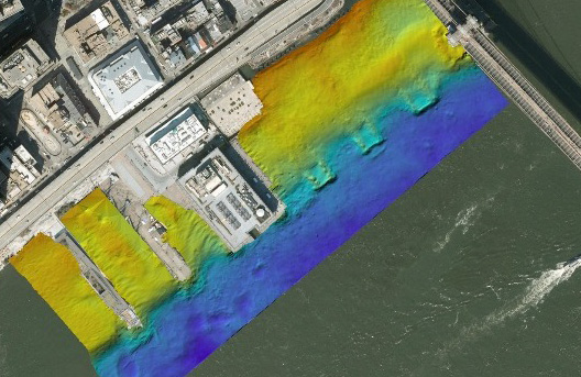
 Safely conducted high-resolution multibeam bathymetric survey using R2Sonic 2024 sonar with integrated GPS and IMU
Collected water column data using YSI CastAway-CTD to support sonar calibration and site condition analysis
Mapped mudline elevations and seawall interface with precision
Processed and refined all data using HYPACK® software; prepared final mapping deliverables in Bently MicroStation CADD
Delivered detailed XYZ point clouds alongside contoured and color-filled bathymetric maps
Pier 15, located along Manhattan’s East River waterfront, sits within one of the most active ferry corridors in New York City. As part of NYCEDC’s initiative to evaluate and upgrade the existing seawall, understanding subsurface conditions at the structure–seabed interface was critical for design feasibility.
As subconsultant, Prudent Engineering was engaged to perform a high-resolution bathymetric survey. Operating from our 22’ Elco survey vessel, the team mapped the harbor floor and seawall interface with precision. Given the site’s proximity to a busy ferry terminal, survey operations required careful planning, real-time awareness, and constant communication with ferry captains to ensure safe data collection without disrupting transit schedules.
The result: a clean, reliable dataset that allowed engineers to assess current conditions and confidently advance design alternatives.