When No Plans Exist: Capturing a Historic Erie Canal Bridge with LiDAR
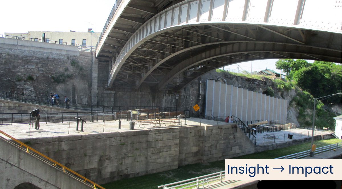
PINE STREET OVER THE ERIE CANAL
By Frederick P. Burgwardt, P.E., Manager | Design | Structure Inspection
When the New York State Department of Transportation (NYSDOT) initiated load rating efforts for BIN 4454160 carrying Pine Street over the Erie Canal, one significant challenge emerged immediately: no record plans currently exist for the bridge.
Prudent Engineering was to collect the field data needed to establish bridge geometry, member properties, bracing, connections, and utilities for downstream load rating analysis.
The Structure
Originally constructed in 1901, the bridge is a historic single-span steel arch featuring riveted built-up members almost throughout, including steel arch ribs with latticed spandrel columns, floorbeams and stringers supporting a concrete deck.
The structure’s complexity and lack of documentation required a detailed field-based approach.
The Challenge
Access to the underside of the bridge was highly constrained. Beneath the structure are multiple generations of canal infrastructure, including:
• The original Erie Canal Locks 69 and 70, part of the original “Flight of Five” lock system
• Portions of the original canal towpath
• The active lock chamber for Barge Canal Lock E34
These conditions made access for conventional hands-on measurements costly, difficult and time-consuming.
The Approach
To overcome these challenges, Prudent Engineering Inspection and Load Rating teams worked closely with our Surveying Department to develop an alternative strategy, implementing multiple setups utilizing LiDAR scanning technology.
The LiDAR scan efficiently captured critical geometric information, including:
• Arch rib geometry and spacing
• Floorbeam and stringer layout
• Spandrel column configuration
• Bracing systems, connection details and member orientations
• Bridge-supported utilities
• Overall span geometry and clearances
To support targeted field verification,
Because LiDAR is not a substitute for all field measurements, targeted “hands-on” verification was also performed using calipers and ultrasonic thickness gauges to confirm member thicknesses, connection details, and areas of section loss. Inspectors deployed a manlift from a flat scow positioned within the Lock E34 chamber, providing limited but critical access to the bridge superstructure elements below deck.
The Outcome
Prudent Engineering utilized a hybrid approach to provide a reliable geometric dataset for structural modeling, to reduce labor effort spent in difficult access conditions and minimize interruption of boat traffic and Canal operations.
By combining advanced scanning technology with targeted field verification, our team efficiently captured the information needed to support evaluation of a complex historic structure.
Have you ever…
At Prudent Engineering, we continue to explore how tools like LiDAR can enhance the way we evaluate, preserve, and extend the life of critical infrastructure.
Have you faced similar challenges with undocumented or complex structures? We’d welcome the conversation.
SYRACUSE, NY
06/05/2026
Prudent Engineering selected as part of NYS DOT’s Largest Construction Project in History
Read more